![](/images/other/stat-length.png)
![Tour Mountainbike La Roche-des-Arnauds - VTT33 - Tour de Clappe - Photo](https://media.geolcdn.com/t/1900/400/0ea0577c-ef1a-4c51-a04f-d5b8c8a4b05f.jpg&format=pjpeg&maxdim=2)
VTT33 - Tour de Clappe
Camping Les Rives du Lac
Les Hautes Alpes à découvrir ! GUIDE+
![Länge](/images/other/stat-length.png)
![Maximale Höhe](https://static1.geolcdn.com/siteimages/upload/files/1508320355ic_sort_altitude_max_24dp.png)
![Positive Höhendifferenz](https://static1.geolcdn.com/siteimages/upload/files/1508320355ic_sort_den_pos_24dp.png)
![Km-Effort](/images/other/stat-length.png)
![Min. Höhe](https://static1.geolcdn.com/siteimages/upload/files/1508320355ic_sort_altitude_min_24dp.png)
![Negative Höhendifferenz](https://static1.geolcdn.com/siteimages/upload/files/1508320355ic_sort_den_neg_24dp.png)
![Boucle](https://static1.geolcdn.com/siteimages/upload/files/16400158638029165_repeat_loop_refresh_sync_direction_icon.png)
![Mountainbike](https://static1.geolcdn.com/sitytour/trail-icons/202.png)
3h12
Schwierigkeit : Schwierig
![Scannen Sie diesen QR-Code, um die Tour in der SityTrail-Anwendung zu öffnen](https://capi.geolives.com/qq0zvz2zws4bq2lad0pu/sitytour/trails/891563/qr.png?size=200)
Kostenlosegpshiking-Anwendung
Über SityTrail
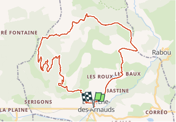
Tour Mountainbike von 26 km verfügbar auf Provence-Alpes-Côte d'Azur, Hochalpen, La Roche-des-Arnauds. Diese Tour wird von Camping Les Rives du Lac vorgeschlagen.
Beschreibung
Vertrek vanuit Montmour, of bij col de Gasparon als je wilt pendelen met de auto ( na het gehucht La Montagne): een heel technische route, maar grandioos. Single tracks over hele smalle paadjes, stukken door alpenweiden, fabuleuze afdaling op de Roche des Arnauds: genieten! Een klassieker uit de " chemins soleil"
Ort
Kommentare
Touren in der Umgebung
![Tour Wandern Manteyer - R14 Pic de Ceuze - Photo](https://media.geolcdn.com/t/375/260/ext.jpg?maxdim=2&url=https%3A%2F%2Fservices.sitytrail.com%2FGeolivesWS%2FDownloadMedia.ashx%3FTrailID%3D890870%26Media%3D0ba1b82b-7041-4a22-9f15-1bc2a79485cb.jpg)
![Wandern Wandern](https://static1.geolcdn.com/sitytour/trail-icons/101.png)
Wandern
![](/images/other/stat-length.png)
![](https://static1.geolcdn.com/siteimages/upload/files/16400158638029165_repeat_loop_refresh_sync_direction_icon.png)
![Tour Mountainbike Manteyer - VTT32 aspremont - Photo](https://media.geolcdn.com/t/375/260/ext.jpg?maxdim=2&url=https%3A%2F%2Fservices.sitytrail.com%2FGeolivesWS%2FDownloadMedia.ashx%3FTrailID%3D894053%26Media%3Dff964c78-0895-4177-a23a-bbf5c1f8ef2b.jpg)
![Mountainbike Mountainbike](https://static1.geolcdn.com/sitytour/trail-icons/202.png)
Mountainbike
![](/images/other/stat-length.png)
![](https://static1.geolcdn.com/siteimages/upload/files/16400158638029165_repeat_loop_refresh_sync_direction_icon.png)
![Tour Wandern Rabou - Rabou Tour du Puy - Photo](https://media.geolcdn.com/t/375/260/805e1ce0-378d-4868-bdbb-2f6f352f7b11.jpg&format=jpg&maxdim=2)
![Wandern Wandern](https://static1.geolcdn.com/sitytour/trail-icons/101.png)
Wandern
![](/images/other/stat-length.png)
![](https://static1.geolcdn.com/siteimages/upload/files/16400158638029165_repeat_loop_refresh_sync_direction_icon.png)
![Tour Wandern Manteyer - Tour de Ceüze - Photo](https://media.geolcdn.com/t/375/260/111429d2-6166-4501-9497-b5a5a3a83e3c.jpg&format=jpg&maxdim=2)
![Wandern Wandern](https://static1.geolcdn.com/sitytour/trail-icons/101.png)
Wandern
![](/images/other/stat-length.png)
![](https://static1.geolcdn.com/siteimages/upload/files/16400158638029165_repeat_loop_refresh_sync_direction_icon.png)
![Tour Wandern Rabou - Pic Melette - Photo](https://media.geolcdn.com/t/375/260/4622a0c3-66f1-414b-9c6c-2d569eb751b3.jpg&format=jpg&maxdim=2)
![Wandern Wandern](https://static1.geolcdn.com/sitytour/trail-icons/101.png)
Wandern
![](/images/other/stat-length.png)
![](https://static1.geolcdn.com/siteimages/upload/files/16400158638029165_repeat_loop_refresh_sync_direction_icon.png)
![Wandern Wandern](https://static1.geolcdn.com/sitytour/trail-icons/101.png)
Wandern
![](/images/other/stat-length.png)
![](https://static1.geolcdn.com/siteimages/upload/files/16400158638029165_repeat_loop_refresh_sync_direction_icon.png)
![Tour Wandern La Roche-des-Arnauds - Pic Chauve - Photo](https://media.geolcdn.com/t/375/260/40b49010-ec4d-4781-90d9-72d51d0c2e2b.jpg&format=jpg&maxdim=2)
![Wandern Wandern](https://static1.geolcdn.com/sitytour/trail-icons/101.png)
Wandern
![](/images/other/stat-length.png)
![](https://static1.geolcdn.com/siteimages/upload/files/16400158638029165_repeat_loop_refresh_sync_direction_icon.png)
![Wandern Wandern](https://static1.geolcdn.com/sitytour/trail-icons/101.png)
Wandern
![](/images/other/stat-length.png)
![](https://static1.geolcdn.com/siteimages/upload/files/16400158638029165_repeat_loop_refresh_sync_direction_icon.png)
![Tour Mountainbike La Roche-des-Arnauds - La Rivière - Photo](https://media.geolcdn.com/t/375/260/0a9ee634-fce3-4af5-9c6a-1f11e946fd54.jpg&format=jpg&maxdim=2)
![Mountainbike Mountainbike](https://static1.geolcdn.com/sitytour/trail-icons/202.png)
Mountainbike
![](/images/other/stat-length.png)
![](https://static1.geolcdn.com/siteimages/upload/files/16400158638029165_repeat_loop_refresh_sync_direction_icon.png)